The activities are as follows:
- Teacher Guide
- Student activity, Graph Type A, Level 2
- Student activity, Graph Type B, Level 2
- Student activity, Graph Type C, Level 2
- Grading Rubric
The Arctic is home to a unique biome, known as tundra. Found at Earth’s northernmost region, the tundra ecosystem is defined by frozen land. Permafrost is a thick underground layer of organic matter, soil, rock, and ice that has been frozen for at least two full years. Each summer as the temperature warms, a thin upper layer of frozen soil thaws, refreezing again the following winter.
Although the tundra might be far away from where most people live, it is connected to the entire globe through the atmosphere. This means it is affected by climate change, just like other places on Earth. In the tundra, increasing temperatures are causing snow to melt and the top layer of permafrost to thaw earlier each year.
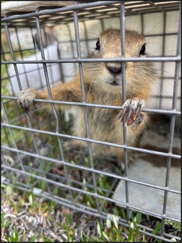
Arctic ground squirrels, also called siksik (pronounced shrick-shrick) in the Inuktitut language, are an important mammal species that call the tundra home. They hibernate for roughly eight months – the longest of any mammal in the world. As they hibernate, the snow and frozen permafrost insulate their burrows and protect them from severe cold. As the summer months approach, the squirrels emerge and move above ground. Their mating season begins immediately after hibernation ends. With only four months out of their burrows, they have to maximize their time!
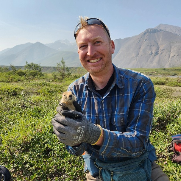
Cory is a scientist who lives in Colorado but travels to the Arctic to do research at Toolik Field Station. For over 25 years, Cory and his research team have been studying the ground squirrel populations. While at Toolik recently, Cory was surprised to discover that male and female ground squirrels were emerging from hibernation on different schedules. He is worried these mismatches could be due to climate change.
This made Cory wonder how ground squirrels know when to come out of their burrow. He suspected that ground squirrels use cues from their environment, such as increasing temperatures, permafrost thaw levels, or the length of time they have been in hibernation. Some of these environmental cues, such as the timing of permafrost thawing, are affected by increased temperatures. Other cues are not affected by temperature, such as the length of time squirrels have been hibernating. If males and females are using different cues, this could be why they are coming out at different times.
To investigate his idea, Cory and his research team turned to data they have been collecting over time. Each year, the research team temporarily captures squirrels. They record each squirrel’s sex, give them a unique ID, and put collars on them before releasing them. The collars can detect light, which is used to know when the squirrels are above ground. For each squirrel, the team records the first date that light was detected after hibernation, called the emergence date. Cory used Julian dates, which start with January 1 as Day 1 and continue to count up by one for each day.
Cory also looked at the data on snowmelt as a potential environmental cue that the squirrels were using. Each year Cory’s team installs cameras on tall towers so that they can use images to measure daily snow cover. When no snow was detected, they measured this as the snowmelt date. Using these two sources of data, they can look for any patterns in emergence dates and spring snow melt.
Featured scientist: Cory Williams (he/him) from Colorado State University and Toolik Field Station. Written by Claire Gunder (she/they) and Rachel Rigenhagen (she/her), Avalon School, St. Paul, Minnesota.